
Digital Cartographies of Spanish Detective Fiction
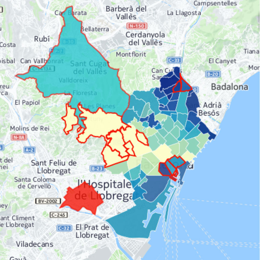
Nick Phillips (Assistant Professor, Spanish, Grinnell College) and undergraduate Margaret Giles have amassed a large collection of maps for their project “Investigating Digital Cartographies of Spanish Detective Fiction.” These maps cover four different novels and can be utilized in two different courses. The summer started off with Giles learning the primary mapmaking program, CartoDB (which changed its name over the summer to Carto), as well as refreshing her skills on Google Maps. She read the first novel and spent the first four weeks making maps based on that text, which is centered on Barcelona. The team stayed with Barcelona for the second novel, and as the weeks progressed, was able to speed up the process and create a similar data set of maps in much less time. After making these basic templates, Giles was able to source local data, such as population figures, GDP per capita, immigration flows, and other economic and social figures, and overlay them onto the maps with the action and movements of the fictional novelistic world also displayed. These maps allow the viewer to contemplate both the “real world” data and the fictional aspects of the novel at the same time, all while highlighting the spatial connections between these worlds.
Giles also developed a way to show character movement by charting waypoints and then animating those waypoints. In this way, the team was able to create visual representations of the detectives’ investigation, as well as maps that incorporated fictional locations that moved based on the chapter in the novel, for example. These maps can be easily edited by future students to focus in on specific segments of the novel under study.
The novels covered in the project were Carme Riera’s Naturaleza casi muerta and Manuel Vázquez Montalbán’s Los mares del sur, set in Barcelona; Juan José Millás’s La soledad era esto, set in Madrid; and Julio Muñoz Gijón’s El asesino de la regañá, set in Seville.
Sample maps: a heat map following the geographies of Naturaleza chronologically and an overview of that novel’s geographical points by section; Los mares del sur neighborhood map with overlaid economic data; and El asesino de la regañá heatmap and neighborhoods.
This project was supported by a Digital Bridges award for a faculty-student pedagogical partnership between Nick Phillips and student Margaret Giles, collaborating with Mike Conner and Rachel Schnepper of the Grinnell Digital Liberal Arts Collaborative and Liz Rodrigues of the Grinnell Libraries.